
When: 10-5-23
Miles: 13
Time: 6 hrs 9 minutes
Where: Hwy 50 – East River Channel
Conditions: Mid 80’s Light winds
Cloudy / Rain showers
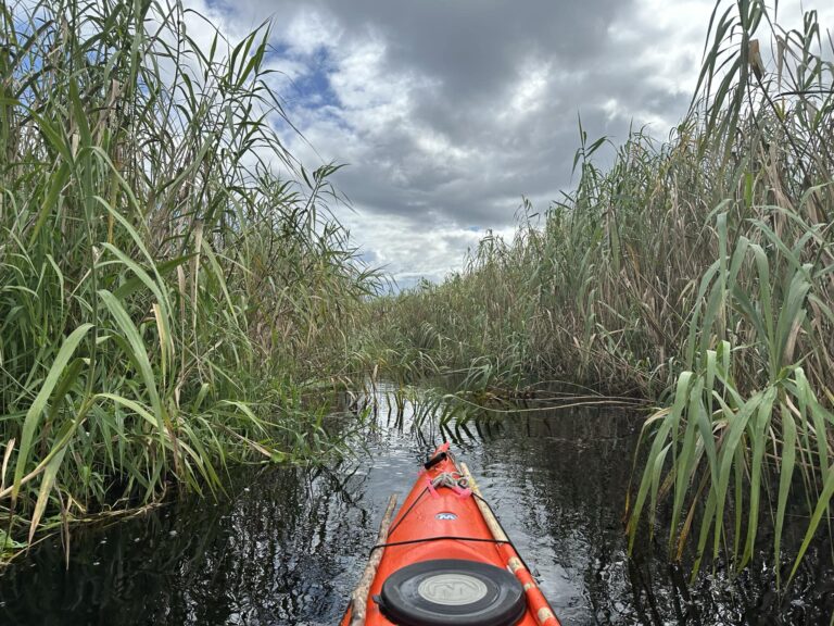
Today’s journey is similar to the trip I took with Ernie Green on
2-25-23. The water levels were low so the gators had plenty
of sand bars and banks to sun on. Ernie counted
over 109 gators, many over 10’ a few 12’.
After 2.5 miles North on the main river channel
we take a narrow tributary (East)
and are immediately swallowed up by the maiden cane
and the Coastal Willows towering over our heads
blocking out the light.
There is no room but for a kayak or canoe
especially overhead as the willows and cane
all lean for the light.
Traveling another secluded 1.5 miles
east deep into the St Johns
we come into the first of 3 large sloughs.
This tangled web of tributaries, river channels,
sloughs and lakes 7 mile across in such a
remote and isolated area is a navigational challenge.
The birds we came to find are here. The White Pelicans, maybe 200.
Great flocks of Greater and Lesser Yellow Legs and of course
all the usual suspects. (see my post on 2-25-23).
Today with all the rains and high-water levels there
are no banks for the gators to sun on
We count maybe a half dozen in the water and maybe a few
dozen birds, most on the wing. Because of deep water the sloughs are empty.
A complete reversal of 8 months earlier.
The main reason I’m here though is to go back to
Indian Fields Mound. This is an Indian midden probably Ais Indians.
The Ais were hunter gathers who flourished for over 10,000 years here in Florida.
Their territory included coastal areas and islands from Cape Canaveral
The Indian River and the St Johns as far South as Fort Pierce.
This Midden (refuge pile) is approximately 6000 years old.
300’ across by 10” high.
I located it last year on a solo paddle from the Hatbill South off SR46.
(Excerpts from my solo trip on 5-16-22)
After 2.5 hours on the river, I find a place on a narrow tributary
where I can get out and hike to the midden.
I run my kayak as far as I can into the thick cord grass
but I still end up 30’ short of the forest edge.
The water level unlike today is low but the muck
(decayed plant matter) is 4’ deep.
Alone I’ve got to be wary. I lay the cordgrass down to walk on, careful
not to fall thru. I make it to the edge of the forest and finally find a way
thru the barricade of fallen trees, limbs and brambles.
Climbing over and under the refuge I find a hog trail that works for a while.
Bushwhacking some 50’ thru a fallen dark forest and then…
In all its seclusion and glory Indian Fields Midden.
The forest is old growth Sabel Palm, Oak, Cedar, Bays…
and dotted with orange trees.
The seeds from these Sour Orange
are from the Spanish soldiers who were each required to carry
100 seeds from the Old World to La Florida centuries ago.
I find these Sour Orange Trees, which the soldiers preferred
scattered thru out the St Johns along with Grapefruit trees
on the few uplands and on the middens.
Sitting on the midden alone, in the still of it all,
I revel in the peace and solitude of a lost civilization.
I stay for quite a while. Although I’m alone
there is a presence with me.
I had searched for this particular midden for some time.
Although it is shows up on some old maps I have,
I’ve been unable to locate it.
My friends at the Historical Society in Cocoa Village are helpful
and are always interested in my journeys on the St Johns.
We talk in length about the history of the river
including the location of the midden. Bob an archeologist for the Society
told me he had been to the midden years before. But his recollection
of the midden was on Ruth Lake and without coordinates
it was another dead-end.
Then last year Joe Dunn of Florida Trailblazer another explorer
exploring the history and wilderness of Florida overland as I do on water
posted the coordinates of Indian Fields after a marathon hike thru
Salt Lake WMA.
Today’s trip is the same as on 2-25-23 except
I take a different tributary into the sloughs
On this trip the plan is to circumnavigate this remote Eastern quadrant.
The river back is new to me.
and is a real challenge. Before cell service was available
I had Southern Photo laminate Google Earth maps of the St Johns to help navigate the
labyrinth of channels and tributaries.
Along with reading the river these maps were our only way thru this wilderness.
Along the way we get hit with a pretty good rain shower.
and I see a young Manatee for only the second time on the St Johns.
Once to the midden we have plenty of water but have
the same problem getting thru the Cordgrass.
We give up on the first attempt and find a better spot
50’ further down.
It’s always an effort on the river in a kayak
but it’s always worth it.
Once there It takes almost an hour to make it to the midden.
But then again Nirvana never comes easy.
With my other English Mate Jason Reed.
(Note: I have pics from all 3 kayak trips)
Mark Nathan
St Johns River Explorer